Visited November 2014
At 5:45 on a Wednesday morning, last November, I had been sound asleep for just 3 hours when Cindy began to nudge me awake.
"Babe. Baaaaaaaaaaabe. Babe wake up."
After working the closing shift for weeks, I was not prepared to be awake at such an hour. My eyes felt heavy and swollen and I turned over with the hope that playing dead would stop Cindy's interruption.
"Babe, TJ's texting you. He's stuck in the mountains and needs to be rescued."
I was now awake, albeit intrigued and confused.

This is TJ. TJ has been my friend for over 15 years now. You might recognize him from last year's post on Crater Lake. A few years ago, his interest in mountaineering and long-distance hiking began to grow. I've personally seen this passion grow from him spending a few hours on the mountains over Los Angeles to 15 days on the John Muir Trail deep in the Sierra Nevada mountain range. It's a really cool hobby that has allowed him to meet some cool people and witness to some pretty spectacular views. Like John Muir or Ansel Adams, TJ hears the call of the wild and returns to the mountains at any opportunity he gets. Literally, any opportunity...
Which brings us to this early morning last November. With just enough signal to text, TJ let me know that after working the closing shift at his work, he hopped into his car and drove overnight to the town of Lone Pine before detouring off onto a dirt road in the eastern Sierra Nevadas. It was there that his car broke down and the only shop in town dumb enough to tow that far into the mountains wouldn't be open for hours. Without knowing if the car would be salvageable and at what price, he began to text around to friends for help in the event he would become stranded. Thanks to Cindy shaking me back and forth, I became that friend.

I set off for Lone Pine with a coffee and his promise of a return payment in the form of food, gas, and an opportunity to hike. I was advised to bring my camera to take beautiful photos of the majestic eastern Sierras, the highest peaks in the continental United States. Clearly he was trying to convince me that my decision to get out of bed was a good one.
After three and a half hours of driving north through the California chaparral, desert, and even a volcanic region, I arrived in Lone Pine. The air was brisk and windy, on which the clouds sailed calmly through the mountains. Luckily, TJ caught a ride down the mountain and to a fast food restaurant, where we met. He clearly hadn't slept since the day before but was in good spirits.
We drove to the auto shop and gave them a description of TJ's car and were told that it would be a few hours.
I asked TJ, "Now what?"
"How about the Visitor Center?", he offered.
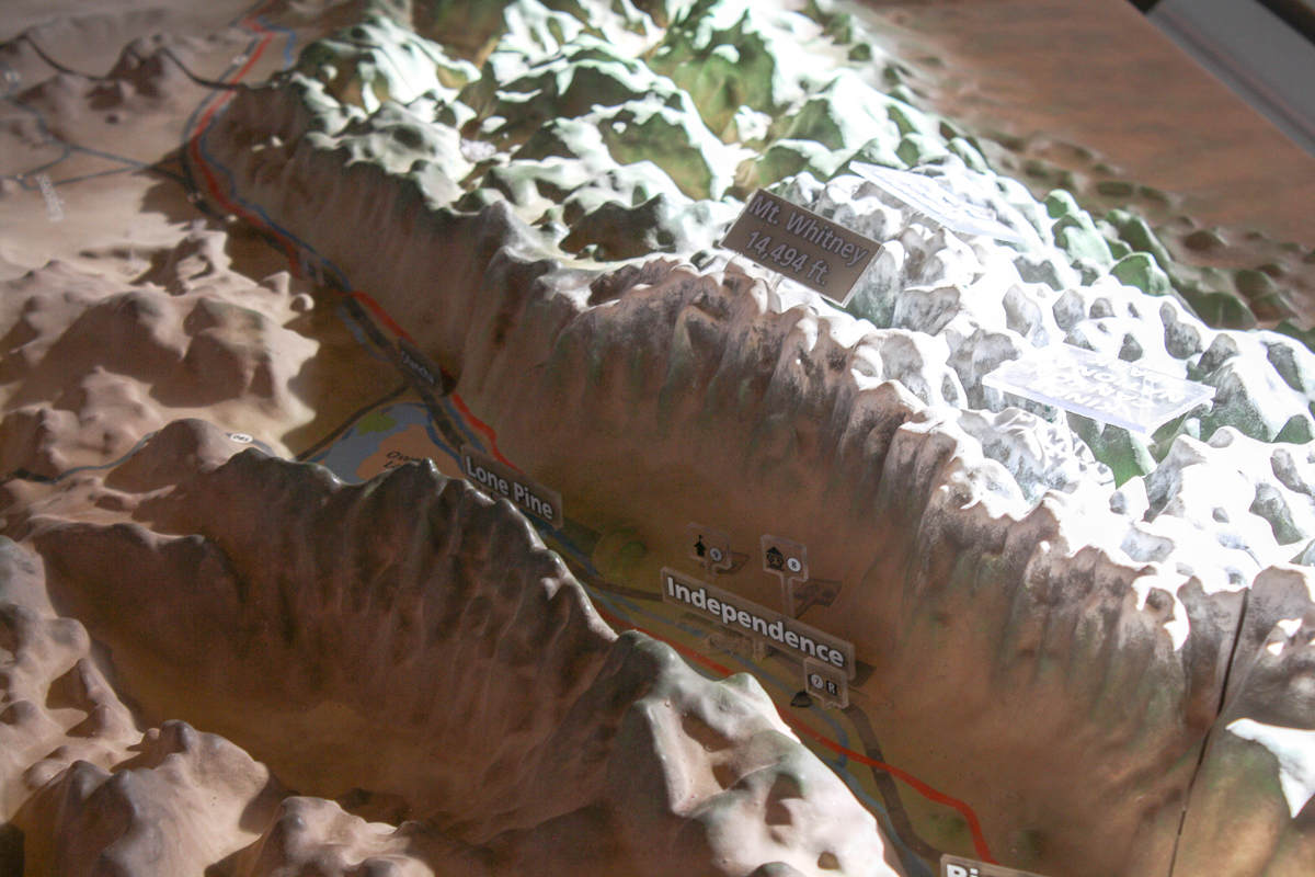
The Eastern Sierra Interagency Visitor Center is a modern building at the southern end of Lone Pine featuring information on Mount Whitney, visible to the east, and Death Valley, about an hour to the west—the highest and lowest points in the continental United States. Additionally, the center features historical information on the neighboring area, a 3D map of California, and also distributes permits for those hoping to climb Mount Whitney.


While TJ chatted with the Rangers about climbers who 'bite off more than they can chew' on these peaks (downplaying the fact that he just stalled a Honda Accord on a mountainous dirt road) I looked around at the information on the region's history. As expected, there was a lot written on the Los Angeles Aqueduct. Lone Pine is located in the Owens Valley, which serves as the controversial start of the aqueduct where precious water from the valley gets diverted to sustain Los Angeles, which does not have a natural water source of its own. I also saw information on a location I knew of and didn't realize its closeness until now—Manzanar.

For those who don't know about Manzanar, first a little history, written by me and sourced through Wikipedia (hardly academic, but just go with me on this!)...
On February 19th, 1942, President Franklin D. Roosevelt signed Executive Order 9066, stating:
I hereby authorize and direct the Secretary of War...to prescribe military areas in places and of such extent as he...may determine, from which any or all persons may be excluded, and with respect to which, the right of any person to enter, remain in, or leave shall be subject to whatever restrictions the Secretary of War...may impose in his discretion.
Basically, FDR's decree, both vague in its intent and clear in its powers, grants the military authorization to evict someone from an area if for a military necessity. The people to be evicted and places to be evicted from was entirely the discretion of the Secretary of War and his commanders.
It was on this authority that the internment of Japanese-Americans would begin. Immediately, U.S. Military would classify much of Washington, Oregon, Arizona, and all of California as a military exclusion zone and began to evict over 110,000 Japanese-Americans (over two-thirds of which were American citizens) from their residences and relocate them to internment camps. Officially, the purpose for the exclusion zone was a defensive strategy (to prevent an uprising by those potentially loyal to Japan) but racial prejudice played a major role.
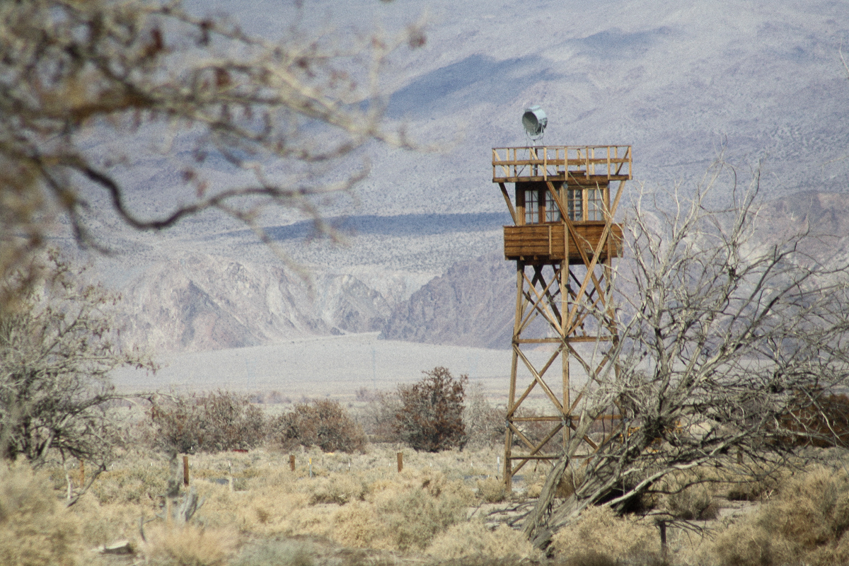
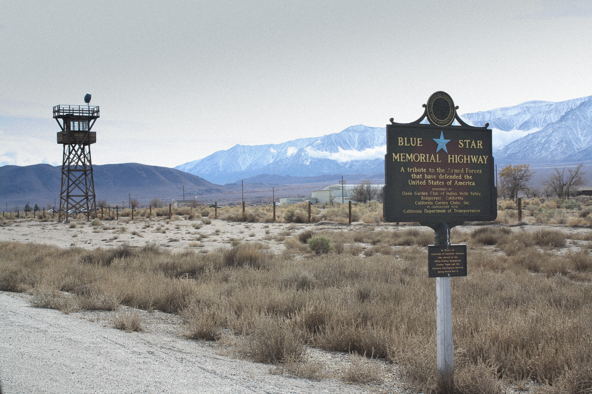
Manzanar was one such "relocation camp". Over 10,000 people were moved here and locked in behind fences, barbed wire, and armed guards. Without privacy and with limited resources in the cheaply-constructed facilities, the Japanese-Americans attempted to reconstruct the sense of a normal life with community events, sports, and through employment at the camp until the camp's closure at the end of the war in 1945.
Today, Manzanar is a National Historic Site and is available to visit through the U.S. National Park Service. The site consists of a few reconstructed buildings (barracks, a mess hall, guard tower), the original historic entrance, the cemetery, and a visitor's center in the middle. The visitor's center was a plain, temporary looking structure in the center of the camp but once entered, was a tremendously honest, expertly crafted, and well researched museum on the history of the camp. From the visitor's center, you could wander around the reconstructed buildings or embark on a self-guided driving tour of the grounds.


We walked around the rebuilt buildings, peering around at the plain and minimal construction. It was so quiet that we could hear only the soft howl of the wind and our footsteps on the hollow, wooden floors. It felt as though we were the only people there. TJ, ever enthralled by the Sierras, commented on how much the bleak conditions contrasted with the beauty and majesty of the mountains. I saw it differently, suggesting that the mountains possibly added to the fences in making those who lived in the camp feel removed from the world, as though they had been dropped into a pit.

What I enjoyed about the Historic Site was not only the openness and honesty through which it held a magnifying glass over this dark mark on America's history, domestic policy, and national brand, but how it forced the visitor to consider its lesson in the modern era. At the back of the visitor's center stands a floor-to-ceiling display listing the 10,000+ names of those who were denied their American liberties in a nation fearful and at war. Standing just before it, a sign contrasts images of the attack on Pearl Harbor and the New York skyline after the collapse of the World Trade Center on 9/11. And above that, the blunt quote of a Founding Father:
“They that can give up essential liberty to obtain a little temporary safety deserve neither liberty nor safety.”
After Manzanar, we returned to the auto shop. TJ's car had made it safely down the mountain and was already up on a lift. With few alternatives in town and the laughable prospect of a bill for a 200 mile tow back to his home, TJ had little choice but to agree with the shop's diagnosis and sign off on the repairs. It would be another hour.
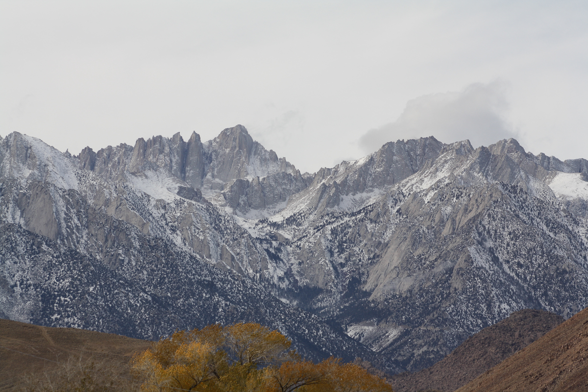
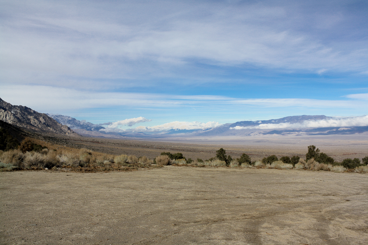
To kill time, TJ recommended that we drive up towards the Whitney Portal en route to the 14,505 feet tall Mount Whitney. Knowing that I'm a shameless tourist and a casual hiker, he knew I would like to see it for myself. Driving up from the valley floor, Mount Whitney doesn't look nearly as impressive as some of the nearer peaks. Whitney's location nestled in the eastern Sierra Nevada range and plain-old forced perspective makes the peak appear as small, jagged spires below the mountains that jut straight out of the valley floor.

Mount Whitney located at the center of this picture.
We drove up to a gate at the base of Lone Pine Peak, a dirt turnaround at an elevation of 6,500 feet. The Whitney Portal road still lay ahead in the form of switchbacks carved into the mountainside, rising up to 8,300 feet. Though we had already driven through a 3,000-foot elevation gain in just 8 miles, I decided to stop the drive there, below the snow line. My poor, under-maintained Honda Fit had already been through far beyond an entire week's worth of strain and I wasn't convinced the view would get much better. I refused to have to call another friend to come rescue the both of us from my failed rescue mission. Besides, there was a great view of the entirety of Owens Valley wrapping itself around the low clouds like a great American Frontier painting.
Starting the drive back down towards Lone Pine, we took several detours through the Alabama Hills. Located 1,700 miles away from Alabama, these hills feature strange, bulbous rock formations jutting out of the ground for miles. Like Vasquez Rocks in Santa Clarita, the Alabama Hills unique formations have a long history of attracting film makers. They have appeared in old westerns like How the West Was Won and The Lone Ranger as well as modern films like Tremors, Gladiator, and Django Unchained. The Alabama Hills even stood in for Afghanistan in the first Iron Man film!
It was clear that the locals are proud of the area's film history. Driving around, we'd find commemorative plaques marking the site of famous film-shoot locations. In fact, Lone Pine even has an annual film festival and the Lone Pine Film History Museum, one of the more prominent buildings in the town of 2,000 people. At the time, I didn't have any interest in visiting the museum but if I ever revisit Lone Pine, I intend to—especially now that I know that they have the dentist wagon from Django Unchained. Either way, the plaques made for nice landmarks as we drove through the alien terrain.


To finish our tour of the Alabama Hills, we parked and set off on a short hike to one of many arches in the area. It was a curious formation and served as a beautiful frame for any photo.


Mount Whitney is framed and visible off in the distance.

At this point, we were approaching 3pm and anticipated that the work would be complete on TJ's vehicle. We drove back down the hill to Lone Pine and stopped at the shop. Sure enough, the car was ready. We entertained the possibility of staying longer but were both growing increasingly tired. With 3.5 hours of driving ahead of us, we figured it would be best to leave and get home for a late dinner. I filled my Fit with gas and air, turned on a podcast, and set off for Los Angeles.
Lone Pine looks just like one of many other little towns you drive through on the 395 through Eastern California. It is small and quaint but there is a dry stillness that makes the town feel old, rough, and not very lively. You can't help but think to yourself, "Who the hell lives here?" and it's easy to drive through in two minutes with little thought. But I kind-of liked it!
Now, I'm convinced I could find anything interesting. It's a gift. But that being said, I'm very thankful for 'TJ's rescue' serving as an excuse to spend some time around the little town because I was able to do and see a lot. It reminded me that I need to slow down when I plan travel because there is so much hiding in little outposts like this. I thoroughly enjoyed spending the day with TJ and his text saved me from a day wasted on TV and Internet. Thank you TJ and thank you TJ's car!
....well, former car. You see, one week later, TJ attempted the same drive. Another over-night trek to the mountains except, this time, there was a large rock in the road....
Now TJ doesn't have a car. Sorry TJ!
For more photos of our day driving around Lone Pine and the Manzanar Relocation Center, check out the gallery below: